


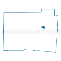
TRENTON TRENTON8 Voting District, Butler County, Ohio
About
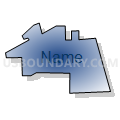
Outline

Summary
| Unique Area Identifier | 643158 |
| Name | TRENTON TRENTON8 Voting District |
| County | Butler County |
| State | Ohio |
| Area (square miles) | 1.16 |
| Land Area (square miles) | 1.16 |
| Water Area (square miles) | 0.00 |
| % of Land Area | 100.00 |
| % of Water Area | 0.00 |
| Latitude of the Internal Point | 39.46568990 |
| Longtitude of the Internal Point | -84.46407510 |
Maps

Graphs
Select a template below for downloading or customizing gragh for TRENTON TRENTON8 Voting District, Butler County, Ohio


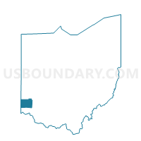
Neighbors
Neighoring Voting District (by Name) Neighboring Voting District on the Map
- MADISON TWP MADISON6 Voting District, Butler County, OH
- ST CLAIR TWP STCLAIR8 Voting District, Butler County, OH
- TRENTON CITY TRENTON1 Voting District, Butler County, OH
- TRENTON CITY TRENTON4 Voting District, Butler County, OH
Top 10 Neighboring County Subdivision (by Population) Neighboring County Subdivision on the Map
- Trenton city, Butler County, OH (11,869)
- Madison township, Butler County, OH (8,448)
- St. Clair township, Butler County, OH (6,908)